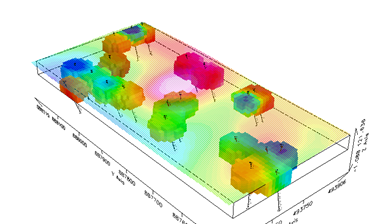
- Double dipole array configurations were used along 8 profiles lines measuring 329m each running east to west to detail the attitude of the interpreted structures below the ground surface for more successful test drilling over the “target area” following the aero magnetic interpretation carried out by Challion
- Two major NS structures were identified from magnetic and radiometric data interpretations. It is observed that the structures corresponds with the IP at two main points delineated on the drilling target map The structures/rock bodies are dipping and must be drilled at an inclined angle of about -70 to -80 degrees to the east.
- The best drilling targets correspond to interpreted magnetic data at the intersection between the NS/NW/NE structure along section line 7 and 8 at 112-126m, 154-161m, and 199-217m. Interestingly these points also correspond to 2 targets marked along NS structures from magnetic data. It shows a possible strike length of 470m.
- 12 drilling targets were marked for mineralization testing and are distributed to cut across the anomalies observed from all the intercepting structures shown on IP sections.